

Google launched Nano Banana 2 inside Google Earth on 30 July 2026, letting any web user type a prompt and rewrite real satellite, aerial or 3D views of any coordinates on the planet. Twenty-four hours later the company rolled the feature back after users shared screenshots of fabricated nuclear plants, bomb craters, collapsed landmarks and border camps that still sat on authentic base imagery.
The episode lasted barely a day yet exposed an irony at the heart of the product: the same authority that made Google Earth indispensable for verification turned every generated scene into a more convincing forgery than a free-standing AI image could ever be.
The Feature That Let Anyone Rewrite the Planet
Product manager Bryan Horowitz’s official launch post and same-day update invited users to “type whatever you want to see.” Suggested uses included restoring Pompeii in 78 A.D., generating real-estate renderings on empty lots, or turning the Mountain View campus into a sci-fi utopia.
The tool worked by grounding Nano Banana 2 generations in Google Earth’s existing imagery layer rather than inventing a scene from nothing. Generated images stayed outside the main shared Earth experience and carried watermarks, including the invisible SynthID invisible watermarking system. Screenshots, however, travelled freely.
- Launch: 30 July 2026, global for Google Earth web, no waitlist
- Rollback: 31 July 2026 after policy-violating screenshots appeared
- Stated reason: “people sharing screenshots of generated imagery that appear to violate our policies”
- Promise: stronger guardrails before any return
Google’s News from Google account posted the climbdown language that same Friday, noting that “people uniquely trust Google Earth for a reliable view of the world.”
Real Coordinates Made the Fakes Harder to Spot
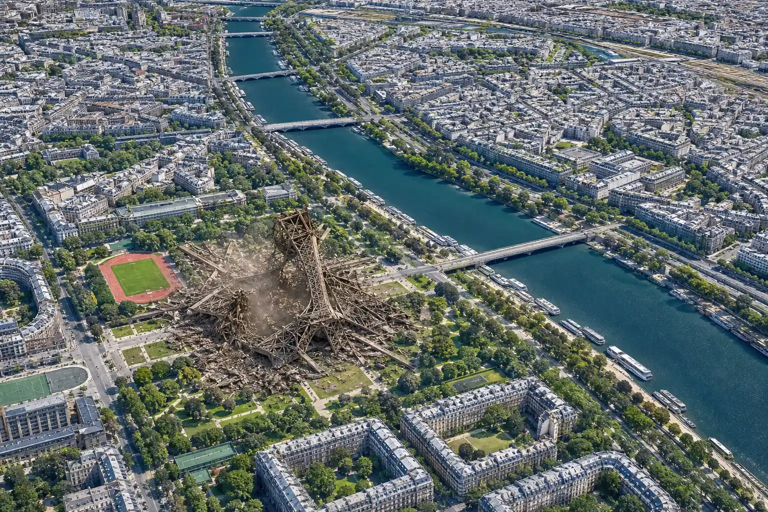
Standalone AI generators often leave wonky roads or misshapen buildings that a quick check against live Earth can catch. Nano Banana 2 avoided that trap. Because the surrounding geography stayed true, a collapsed Eiffel Tower or a new crater next to a Gaza hospital still lined up with every genuine landmark around it.
BBC Verify tested the feature before the pull and produced a sinkhole swallowing the Great Pyramid, Russian tanks in Kyiv, and a collapsed Eiffel Tower. AI and misinformation researcher Henk van Ess of Digital Digging generated a nuclear plant in Iran, a refugee camp on the US-Mexico border, and a hospital-plus-crater scene in Gaza, all from single-sentence prompts.
| Intended prompt examples | Actual misuse examples produced |
|---|---|
| Historic Pompeii street scene | Non-existent nuclear plant in Iran |
| Lakeside dream home on empty lot | Fake refugee camp at US-Mexico border |
| Community garden or retail district | Hospital and bomb crater in Gaza |
| Futuristic campus makeover | Collapsed landmarks and burning sites |
Van Ess put the core problem plainly: the forgery “inherits the credibility of the map it was born on.” Small prompt tweaks also bypassed some of Google’s initial harmful-topic filters.
Who Relied on the Unedited View
For two decades Google Earth has served as a shared baseline for people who cannot afford private satellite tasking. The list is short and consequential.
- Investigative journalists and open-source intelligence teams verifying claims in conflict zones
- Fact-checkers such as BBC Verify matching user-generated video to terrain
- Emergency responders and human-rights monitors tracking floods, fires or destruction
- Courts and researchers treating dated imagery as a public record
Bellingcat’s landmark work on the 2014 downing of Malaysia Airlines MH17 remains the textbook case. Russian Ministry of Defence satellite images were compared against Google Earth’s dated archive; the discrepancies helped prove fabrication. The group’s own guide still asks the blunt question that once had a clear answer: who to trust, Google or the Russian MoD? That comparison method is detailed in Bellingcat’s 2015 MH17 verification guide.
Geospatial analyst Bill Greer told BBC Verify that satellite imagery has historically been seen as an especially trustworthy source. Once the public learns the view can be rewritten by prompt, the baseline itself becomes suspect even after the button is removed.
Centuries of Map Trust and One Mountain Range That Refused to Die
James Cheshire, professor of geographic information and cartography at UCL, placed the episode inside a longer history of cartographic error and lingering belief. In the 1790s explorer Mungo Park described a possible mountain chain to cartographer James Rennell. Rennell drew the Mountains of Kong across West Africa. The range appeared on maps for more than a century.
- 1790s: Mungo Park’s account reaches James Rennell; Mountains of Kong enter European maps
- Late 19th century: Doubts grow; French officer Louis-Gustave Binger’s 1887-88 expedition proves the range does not exist
- 1936: “Kong Mountains, French W. Africa” still listed in the Oxford Advanced Atlas index
- 2001-2005: EarthViewer3D launches, Google acquires it, Google Earth relaunches and begins accumulating public trust
- 30-31 July 2026: Nano Banana 2 appears and disappears inside the same platform
False mountains outlasted their disproof by decades because maps shape how people see the world. Cheshire notes that early copyright cases over nautical charts even supply language now cited in AI training debates: improvement is allowed, servile imitation is not. The parallel is imperfect, yet the durability of a cartographic fiction remains instructive.
What the Climbdown Admitted
Ed Parsons, who spent years as Google’s geospatial technologist, wrote the sharpest internal-adjacent critique. In his post he recalled the old internal description of Earth and Maps as “a mirror of the real world.” That principle, he said, was “structurally shattered this week.” The full former Google geospatial technologist’s account blames a broader corporate panic to “add AI to everything” without regard for a product whose equity is objective truth.
We used to describe Google Earth and Maps as a mirror of the real world … That absolute bedrock of trust was structurally shattered this week.
Parsons argued that veterans of the geo team understood an unwritten rule: geospatial trust is hard to win and terrifyingly easy to lose. Newer arrivals treated Earth as another canvas waiting for generative features. The result was a feature that felt fun in a product-management deck and reckless the moment it met the open internet.
Google’s own language conceded the point. The company did not defend the experiment as a net positive that simply needed better filters; it pulled the capability outright and emphasised the unique trust users place in the platform.
A Permanent Question Mark Over Every Screenshot
The feature is gone. Screenshots of the fakes already exist. Watermarks can be cropped. Detection tools sometimes fail or can be tricked, as BBC Verify demonstrated with Gemini itself. Future images that look like Google Earth will carry a new layer of doubt even when they are genuine.
That is the lasting cost of the irony. A tool sold as a way to visualise history or dream homes also supplied bad actors with location-anchored fabrications that required almost no technical skill. The rapid retreat showed that even the most AI-enthusiastic companies still rank trust higher than feature velocity when the product is a planetary reference layer. Yet the knowledge that the button once existed cannot be unlearned.
Google Earth continues to add lighter experiences, including a free web-based flight simulator addition and collections of bizarre real-world sightings catalogued in Earth. Those remain playful overlays on an unedited base. The Nano Banana episode proved how quickly that base can be compromised when generation is bolted directly onto it.
Mapmakers spent centuries building and defending the idea that a good map is a reliable view of the world. Google spent two decades turning satellite photons into a public mirror. One fruit-named model showed how fast the reflection can crack.
Frequently Asked Questions
What exactly was Nano Banana 2 inside Google Earth?
Nano Banana 2 is Google’s generative image model. Inside Earth it let users zoom to any real location on the web version, click “create image,” and type a text prompt that rewrote the satellite, aerial or 3D view while keeping surrounding geography intact. Outputs were watermarked and stayed private to the user until screenshots left the platform.
Why did watermarks and policy filters fail to contain the problem?
Visible and SynthID watermarks could be cropped from screenshots before sharing. Harmful-topic filters blocked some blunt prompts but accepted milder rewordings of the same idea. External detectors and even Gemini itself could sometimes be fooled into treating the results as real satellite imagery.
How did the Mountains of Kong stay on maps for so long?
After Mungo Park’s 1790s description, cartographer James Rennell placed the range on widely copied maps of West Africa. French explorer Louis-Gustave Binger proved in 1887-88 that the mountains did not exist, yet the name still appeared in the 1936 Oxford Advanced Atlas index, showing how cartographic errors can outlive their disproof by decades.
How did Bellingcat use Google Earth against the Russian MH17 images?
In 2014-15 Bellingcat compared Russian Ministry of Defence satellite photos of the MH17 crash area against dated Google Earth and DigitalGlobe archive imagery. Differences in features and dates helped demonstrate that the Russian images had been fabricated, establishing Google Earth as a public verification baseline.
Will the image-generation feature return to Google Earth?
Google stated it is working on stronger guardrails and may restore a version later. No return date or revised design has been announced as of early August 2026. Any future release will face heightened scrutiny from the same OSINT and newsroom users who forced the original withdrawal.