
Ten days before the 2026 FIFA World Cup kicks off, the mobility simulation work is finished and the real exam is about to begin. Planners across 16 host cities have spent months modeling how more than five million fans will reach 104 matches by car, rail, metro, bus, bike, and on foot. Now the models meet match day.
On screen, the plans look convincing. Crowds disperse, screening lanes clear, metro platforms refill on schedule. The tournament will be the first time those plans run at full scale across three countries at once, and the gap between a tidy simulation and a humid June evening with 78,000 people trying to leave at the same moment is where the story actually sits.
The Five-Million-Fan Stress Test Begins in Days
The tournament that starts on June 11 with Mexico against South Africa at Mexico City’s Estadio Azteca is the largest in the event’s history by almost every measure. It runs 39 days, ends with the final at MetLife Stadium in the New York and New Jersey area on July 19, and spreads play wider than any World Cup before it.
That scale is the reason mobility planning moved from a logistics afterthought to a front-line concern. Hilary Aylesworth, chief product and technology officer at Umovity Software by PTV Group, frames the challenge as a textbook case for simulation, where tens of thousands of people have to move safely in and out of a venue within a narrow window.
- 104 matches across the United States, Canada, and Mexico over 39 days
- 48 teams, up from 32 at the last edition, the first World Cup at this size
- 16 stadiums, split 11 in the US, three in Mexico, two in Canada
- 78,000-plus spectators expected per match at the New York and New Jersey venue alone
Why 16 Cities Make This World Cup a Mobility Outlier
Past tournaments concentrated crowds in one country with a single transit culture and one set of rules. This one asks Vancouver, Mexico City, and Miami to deliver the same outcome across wildly different transport systems, climates, and parking habits, often in the same week. The host committee published the full breakdown on the official 2026 World Cup host city list, and the spread is the point.
Several of the 16 host cities rushed permanent transit upgrades to be ready in time, which is exactly the kind of expensive, hard-to-reverse decision simulation is supposed to de-risk. The pattern echoes how Southern California is leaning on venue planning for the next mega event, including Long Beach and Carson’s role in the 2028 Los Angeles Olympics.
| Host city | Transit upgrade for the tournament | Match-day constraint |
|---|---|---|
| Atlanta | Redesigned bus network, new bus rapid transit (BRT, dedicated-lane express buses) line | Heavy reliance on transit to the downtown stadium |
| Los Angeles | County metro subway extension opening before matches | Notoriously car-dependent travel base |
| Seattle | Final light rail segment completed to the downtown stadium | Construction pause during the tournament window |
| New York and New Jersey | Coordinated shuttle, rail, and rideshare network for 78,000-plus per match | No public parking at the stadium |
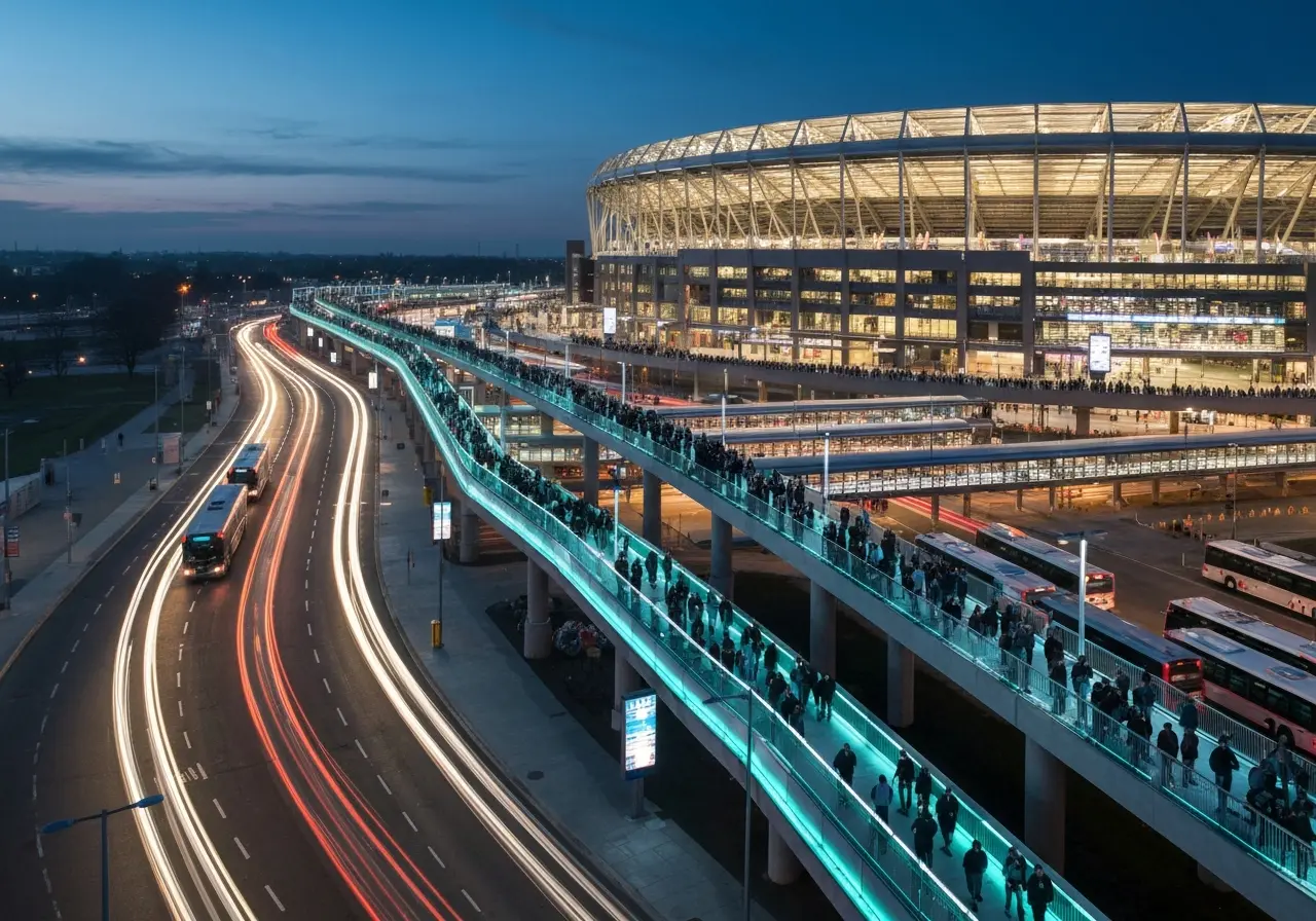
From Sofa to Seat: How the Simulations Model a Fan’s Whole Trip
The selling idea behind the modeling is what Aylesworth calls a sofa-to-seat approach, simulating the entire visitor journey rather than just the moment at the turnstile. A fan leaving home is tracked through the parking lot or subway station, along the pedestrian bridge, through the security line, and into the bowl, then back out again when the whistle blows.
Every Fan as an Agent
Pedestrian behavior runs on a Social Force Model, the engine inside PTV Viswalk. Each person becomes an individual agent pushed toward a destination while reacting to other people, walls, and obstacles through calibrated forces, with a small random term so crowds do not all pick the same gap at once. That granularity is what lets planners see a queue form before it forms in real life.
One Model, Many Modes
Vehicles, trains, cyclists, and walkers all live in one simulation through PTV Vissim’s multimodal traffic simulation, so a late train and a backed-up drop-off lane can be tested together rather than in isolation. The synthetic-scenario logic mirrors a wider shift in the field, visible in Gatik’s use of NVIDIA simulation for autonomous trucks, where rare and risky situations get rehearsed in software first.
The journey breaks into stages planners model one by one:
- Arrival at parking lots, metro and rail platforms, and drop-off zones
- Approach across pedestrian bridges, sidewalks, and crossings shared with vehicles
- Screening at security checkpoints, where queues build fastest
- Seating and concourse circulation, then the reverse surge at full-time
What Maracana Taught Planners in 2014
The method has a track record worth trusting, and it is grim where it matters. At the 2014 World Cup in Brazil, crowd simulation flagged stadiums where evacuation times ran past international safety standards before anyone set foot inside.
At the Maracana in Rio de Janeiro, the modeling showed exit ramps too narrow to clear the expected crowd in time. Widening them measurably improved pedestrian flow and brought evacuation performance back within the required limits. That is the case the vendor leans on when arguing the tool does more than smooth a commute.
Major events create highly dynamic transport situations. Ensuring the safe and efficient movement of tens of thousands of people inside and outside the venue is a classic use case for multimodal simulation.
That was Aylesworth, describing why the same playbook from a decade ago in Brazil is being scaled across a continent now. The technical reasoning behind those evacuation tests is laid out in PTV Viswalk’s pedestrian simulation FAQs.
Stockholm’s 45,000-Person Rehearsal
A more recent example shows the planning value rather than the life-safety one. In Stockholm, consultants at the engineering firm WSP simulated how up to 45,000 visitors would move through an arena district during major events, tracing flows between venues, checkpoints, pedestrian bridges, metro stations, and the public spaces around them.
The study found bottlenecks at screening zones and transit access points, then turned those into concrete fixes: more screening capacity, better pedestrian infrastructure, and higher metro frequency. The detailed egress work is documented in the firm’s Stockholm arena crowd simulation case study.
“One of the key insights from the simulation was that we needed additional security screening zones during events to prevent queues from building up,” said Frida Aspnas, transport consultant at WSP, speaking in a recent webinar.
The Real-Time Layer When Models Meet Match Day
Simulation ends when the event begins. From there, the job shifts to live monitoring, and the toolset shifts with it. PTV Flows pairs live and historical traffic data to spot unusual patterns, forecast congestion hotspots, and surface disruptions early enough to act on them.
The point of that data is decisions made in minutes: retiming signals, prioritizing buses, rerouting traffic, or pushing alternative routes to travelers before a jam locks in. It is the difference between planning for a scenario and steering through the one actually unfolding.
Host cities are already bracing the public for friction. New York identified eight match-related dates as severe-congestion days, and the city’s coordination with regional transit agencies is detailed in the Midtown transportation plan for World Cup matches, which sets up dedicated corridors and declares each match day a gridlock alert. There will be no public parking at MetLife Stadium, a decision that forces tens of thousands onto rail and shuttle services and is spelled out in the regional stadium mobility plan for the New York and New Jersey venue.
Those eight gridlock alert days are the public-facing admission that no model survives contact with reality untouched. The plans assume fans follow the routes they are given; some will not.
The Gap Between a Model and a Match Day
The honest read on all of this is that simulation narrows uncertainty without erasing it. A calibrated agent does not miss its train because it stopped for a beer, and it does not all decide to walk the same bridge because a rideshare app surged. Weather, a late kickoff, a security scare, or a single closed metro line can push real crowds off the modeled path in ways the software can flag but not prevent.
What the tournament offers, then, is the biggest validation set the industry has ever had. Sixteen venues, dozens of operators, and three weeks of nightly peaks will produce a flood of evidence on where the planning held and where it cracked. Cities watching from outside, including the ones lining up for 2028 and beyond, will read those results closely.
If the screening lanes, shuttle bays, and metro headways behave the way the agents did on screen, the planners get a quiet tournament and a method worth keeping. If the crowds find a bottleneck the model missed, the correction will happen in real time, on camera, in front of the largest World Cup audience yet.