
A private off-road park in the Texas Panhandle now holds a terrain dataset most national governments would recognize. MERUS Adventure Park, a 5,500-acre outdoor destination inside Palo Duro Canyon, has had every rock face, switchback and canyon wall across its 68-mile trail system captured by drone-mounted LiDAR (Light Detection and Ranging, a laser surveying method that builds a 3D model from millions of range measurements). The survey, flown by Austin aerial intelligence firm ClearedDirect, resolves the entire property down to half a centimeter. By the park’s own account, it is the first private adventure park in the United States to map its terrain at sub-centimeter resolution.
That headline reads like a quirky use of expensive hardware. The more useful way to read it is as a signal. The same precision once locked inside federal land management, mining and infrastructure engineering just showed up on a recreation property that sells trail passes, and the gap between those two worlds is closing faster than the recreation industry has noticed.
A Texas Off-Road Park Just Logged Federal-Grade Terrain Data
The June 2 announcement bundled three Texas companies into one project. MERUS supplied the land and the operational problem. ClearedDirect supplied the survey. Golden Hour Technologies, an Austin software company, supplied the layer that turns a static map into a working tool. Each piece is ordinary on its own. Stacked together on a single property, they describe a template the outdoor industry has not had.
MERUS is not a hobby plot. Founded in 2021, it ran more than 8,000 visitors from all 50 states and Canada through its gates in 2025, across a trail network rated beginner to expert, plus primitive campsites, full-hookup RV sites and canyon-view cabins. A property at that scale carries real liability and real conservation duties, and until now it managed both the way almost every park does, through hand-drawn difficulty ratings and radio check-ins.
Pete Newell, a partner at MERUS Adventure Park, described what the three firms built as something that “isn’t a single feature” but rather “infrastructure.” That word choice matters, because infrastructure is exactly the category of buyer LiDAR firms have always chased. A recreation operator using the language of pipeline and bridge surveyors is the tell that the customer base is widening.
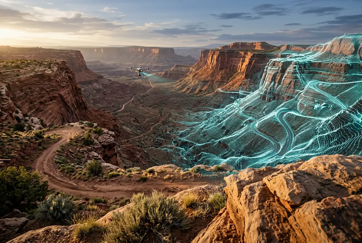
What 0.5-Centimeter Precision Captures Across 68 Miles
ClearedDirect flew the survey with the YellowScan Voyager, a long-range sensor built around a RIEGL VUX-120 laser scanner. The published figures explain why the park describes the output the way it does. The system delivers 0.5 cm RMS precision (root mean square, a standard measure of how tightly repeated measurements cluster) while firing up to 2.4 million laser shots per second.
Reading the Ground Through the Canopy
The detail that separates this from a drone photo is multi-return capture. The Voyager records up to 32 echoes from a single laser pulse, so the beam can clip a juniper branch, then mesquite below it, then bare rock, and the software keeps all of it. That is how canyon vegetation gets stripped away to model the actual earth surface a vehicle has to climb. A 61-megapixel RGB (red-green-blue) camera flies alongside the scanner, wrapping the resulting point cloud in true color so a trail obstacle looks like itself, not an abstract blob.
From Word of Mouth to a Reusable Dataset
The practical jump is from description to specification. A difficulty rating tells a driver a trail is hard. A sub-centimeter point cloud tells the park the exact height of a ledge, the precise pitch of a descent, and how both have shifted since the last storm. MERUS plans to feed the dataset into its partnered mapping platforms and its STAGE5 professional off-road training curriculum, where obstacle dimensions can now be stated rather than estimated.
| Attribute | Traditional park practice | MERUS platform |
|---|---|---|
| Terrain detail | Hand-drawn ratings, word of mouth | Colorized 3D point cloud at 0.5 cm precision |
| Field operations | Radio check-ins, manual coordination | Live telemetry plus self-healing mesh radio |
| Data permanence | Resets with each season | Reusable dataset compared over time |
Why the Map Signals a Geospatial Rotation
This is where the park story becomes an industry story. Survey-grade LiDAR has been a high-cost specialty for two reasons: the hardware and the post-processing. Industry estimates put a capable system near $75,000, with software licenses adding another $20,000 to $30,000 each. Those numbers kept the technology inside clients who could amortize it across bridges, mines and utility corridors.
The market is moving in the direction that breaks that wall. Research tracking the LiDAR mapping market size and forecast values the segment near $2.58 billion in 2025 and projects it past $15 billion by 2033, a compound annual growth rate of about 25% (CAGR, the smoothed yearly pace). Volume at that scale drags prices down, and falling prices are what let a recreation operator buy a capability that used to belong to a state agency.
This project is a proof of concept for what geospatial technology can do when it moves outside its traditional industries.
That line came from Jason Milewski, chief executive of ClearedDirect, and it is the whole thesis in one sentence. The same shift is visible in heavier infrastructure, where real-time geospatial data is being pushed into resilient infrastructure planning. A canyon trail park and a national utility grid are now reaching for versions of the same toolkit.
Why the Buyer Looks Different Now
The older buyers measured return in regulatory compliance and engineering risk. MERUS measures it in guest safety, conservation tracking and training revenue. When a tool’s value proposition translates cleanly across buyers that unrelated, the addressable market is no longer the original vertical. It is anyone who manages a large, complex piece of ground.
The Software Layer That Acts on the Terrain
A map nobody can use in the field is a poster. Golden Hour Technologies, a veteran-led firm founded in 2024 and currently in field trial at MERUS, exists to keep that from happening. Its platform sits on top of the terrain data and adds live telemetry, AI-assisted decision support, and communications built to survive the dead zones that define canyon country.
The communications piece is the unglamorous core. Cell coverage inside Palo Duro Canyon is patchy at best, and a guest-safety call cannot wait for a signal. Golden Hour’s answer is a radio-agnostic, self-healing mesh radio network that staff can stand up themselves, plus configurable workflows that let the park automate its own coordination without a software team on call.
Ian Newell, founder of Golden Hour Technologies, framed the goal in operational terms, saying the combination lets a park “stop reacting to your terrain and start managing it.” Pair the live layer with the static map and the park gains something closer to an air-traffic view of its own backcountry, knowing where assets are, what the ground does there, and how to reach the people on it.
Who Gains Beyond the Trailhead
The park is the headline customer, but the same dataset quietly serves several parties that never bought a trail pass. That breadth is the strongest argument that this is a category in motion rather than a one-off marketing spend.
- Search and rescue teams gain a colorized 3D model of terrain and a mesh network for coordination in an area where cell service fails when it is needed most.
- Conservation managers get a baseline they can re-fly and compare, turning erosion, vegetation loss and trail damage into measured change instead of anecdote.
- Insurers and liability carriers can price risk against documented obstacle specifications rather than subjective difficulty ratings.
- Other private parks get a working reference build, lowering the perceived risk of being second.
None of those beneficiaries are exotic. Every large outdoor operator in the country has a search-and-rescue exposure, a conservation obligation and an insurance bill. A tool that touches all three from one survey is the kind of thing that spreads once one operator proves it runs.
What Could Keep It From Spreading
Caution belongs in this story too. MERUS is one property, Golden Hour is in field trial rather than full deployment, and a single proof of concept is not an industry standard. The most honest read is that the pieces work together at one site and the wider verdict is still open.
Cost remains the gatekeeper. Even on a falling curve, a survey-grade system plus processing software is a five-figure-plus commitment, and a regional trail park with a thin margin will weigh that against fences and fuel before it buys a point cloud. The data is also only as valuable as the discipline behind it; a dataset that is never re-flown or never wired into daily operations decays into an expensive snapshot.
There is a skills gap as well. ClearedDirect delivers NDAA-compliant (National Defense Authorization Act, the US procurement standard for trusted hardware) datasets that infrastructure clients know how to exploit. A recreation operator has to learn what to do with millions of points, which is exactly the gap Golden Hour is trying to fill, and exactly the part that has to prove out across more than one canyon.
For now the test is concrete and local. If the MERUS build holds through a full operating season and a real field incident, the case for the next park gets easier to make. If it stalls in the trial, survey-grade LiDAR stays where it has been, and the rotation waits for the price to fall a little further.